Monday, March 5, 2012

A short trek through Big Horn country...

Waiting for Spring…

An old cottonwood along the banks of the Kettle River reaches up into the cold, early March sky. Not much thawing of the ice flows today. Snow lay deep along the trail. Listening close I could hear the whisperings of ice and water as the river enters the transition from the cold season to one slightly warmer. For a moment the thick clouds parted and rays of sunshine found a distant mountain. It soon passed. The message was clear – not today, not today…


Trekking around in big horn country again today. What a difference one day and a bit of warm sunshine make. Temperatures near 50* give a feel that this winter may be relinquishing it’s near four month grip on the Kettle River Valley.

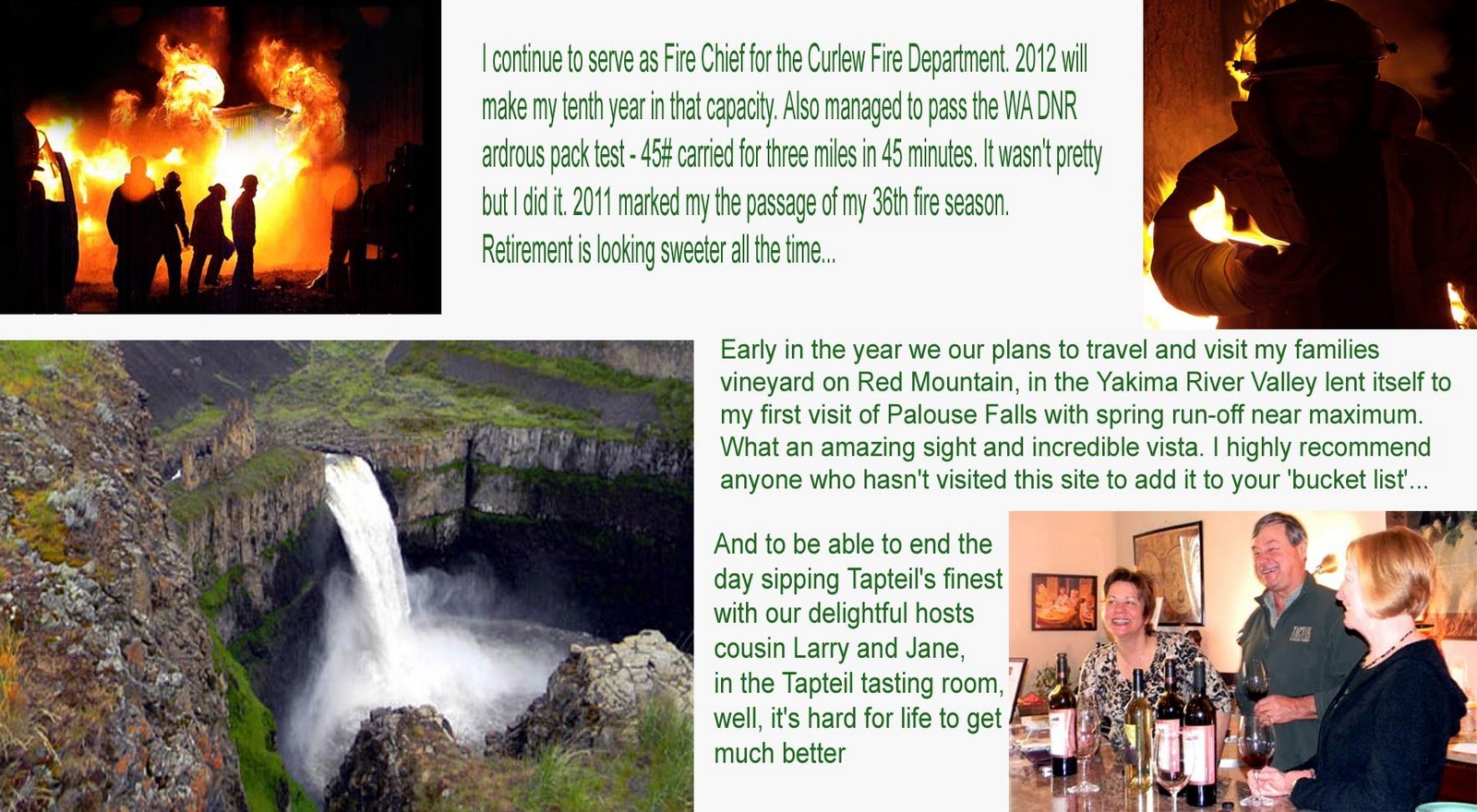
Here are some images (remember to double click to see the photographs in larger format)…
Mary’s Dome, a prominent feature in the upper Kettle River valley, on the SW flank of Vulcan mountain.

As the ice recedes the lichen grows. Such is the way on these vertical south faces along the banks of the Kettle River. Later in the year temperatures will be so hot that the lichen will all but vanish, drying and shriveling to naught as there will be no moisture to be found during the hot.

Below the ice and lichens, on a very wet, south facing rock wall, the mosses grow thickly.  Look closely and you can see several trickles of water dripping through the dense, wet moss. The sound of small, cascading waters were prevalent along this cliff line.
The Oregon Grape are in full ‘red’ as winter’s grip leaves the steep and rocky south slopes of Little Vulcan Mountain.  The white snow, red leaves and speckled rock made for a strong composition of the natural elements.
Lichened rocks, red leaves, distant cliffs, towering Ponderosa Pines and a shear rock wall, what’s not to like on a sunny afternoon trekking about in the mountains? Given this was the warmest day of this winter, the ice falls that had frozen onto the vertical rock faces were melting and breaking loose, often tumbling 100+ feet from the rock above. Hundreds of pounds of ice crashing down and shattering thousands of small pieces on the rocks below. Made for an interesting hike.
Pinja pup on a boulder that several years ago came to an abrupt stop against this young tree (which still bears the scars).
An image of a cottonwood starkly silhouetted in the winter’s afternoon sunshine…
These three rocks, still frozen into the Kettle River remind me of a Japanese sumi drawing.  That simplicity of form, the stark contract of light and dark, the line of composition
Pinja on guard…

It was a strenuous day, hiking about in the mountains. Walking was a combination of post-holing thru snow, skiing on loose rocks, sliding on hard crusted ice and slipping in muck. But the warm sunshine made up for it all…


To close a fine afternoon we had this pileated woodpecker visit as we were walking back to the rig….


Thanks for checking in...

Saturday, February 4, 2012

Okanogan Highlands in Winter...

The diversity of the Okanogan Highlands, (spelled and pronounced
Okanagan in Canada) an international area between southern British Columbia, Canada and Northeastern Washington State, U. S.A., is vast. Spanning an area of over 5 million acres, with multiple mountain ranges including the Monashee, the Kettle River range, the Okanogan Range and the northeastern foothills of the North Cascades this area encompasses a layering of complex eco-systems. Rivers in the area include the Similkameen, the Okanogan, the Kettle and the Columbia. This album will focus on the winter season of the Okanogan Highlands, which lasts from late October through April (elevation specific).
Remember to double click on an image to see the larger version.
The wildfire scars of 7,140'  Copper Butte in the Kettle River Range are easily seen as winter blankets the mountain steppes. This landscape is representative of the eastern reaches of the Okanogan Highlands in Ferry County.
Photo by J. Foster Fanning
* * *
Forests in the Okanogan Highlands, Winter

The forests of the Okanogan Highlands vary by elevation, aspect and geographic location within the Highlands themselves. Mid, southern slopes can be a mixture of open spaced, towering Ponderosa Pines and encroaching Douglas Fir with the higher regions giving way to Lodge pole Pine and Alpine Fir. Mountainous wetlands are usually cottonwoods with large, branchy Spruce. Quaking Aspen groves are found on moist but open slopes. The hot, dry summers and heavy fuel loading on many of the mountain slopes equate to a fire prone ecology in these highlands. Many of the panoramic photographs I post of this area show the scars where large scale forest fires have traversed the landscape.
A dense stand of aspens mixed with cottonwood, scrub birch, and wildrose, during an early winter snow storm in the Kettle River Valley of the Okanogan Highlands. Photograph by J. Foster Fanning

On the mountain slopes above the riverside village of Curlew in Ferry County a ridgeline forest of open Ponderosa Pine is shrouded in winter mists after a warm, wet snowfall.
J. Foster Fanning, photographer


* * *
Summits in the Okanogan Highlands, Winter

Ferry County, Washington, contributed to a total of 120 named mountain summits and peaks in the Okanogan Highlands. Okanogan County adds another approximate 80 named mountains. My personal expertise is skewed toward the United States side of the highlands and I do not have an accurate account of the number of named summits and peaks in the Canadian portion of the highlands.


Mount Bonaparte, at 7,257 feet (2,211.93 meters) is located in northeastern Okanogan County, Washington State. This lone summit monadnock is the highest peak in the Okanogan Highlands south of the Canadian border. Mount Bonaparte is within the Okanogan / Wenatchee National Forest and has a fire lookout tower in it’s summit still staffed during the summer season.
Big White Mountain summit at 7,595 ft, (2,315 m) is the highest mountain of the Okanogan Highland. This peak also dominates Beaverdell Range which lies between the Okanogan Valley to its west and the main spine of the Monashee Mountains to its east. Big White lies between the head of the Kettle River and the source of Damfino Creek.
Photography ~ J. Foster Fanning
In Progress - Please check back soon...
Foster


Saturday, January 14, 2012

The Holiday Letter (just a little bit late)...

These pages, primarily meant for family and close friends,  will read a little better if you double click on them to open them up. Hope you enjoy...