Wednesday, December 14, 2011

Transportation Ferries in Eastern Washington

Not all public transport ferries in Washington State are in the coastal areas:

Given the recent, unusual opportunity to ride both of Eastern Washington’s vehicle carrying ferries on the same day, I decided to do this post to capture that experience but more importantly look at the vital services these two ferries provide to their respective communities and delve into a little of their histories.


Lets first address Eastern Washington’s two vehicle carrying ferries in order of general usage:


1. The Keller Ferry – vessel name: Martha S.


2. The Gifford / Inchelium Ferry – vessel name: Columbia Princess


Both of the above ferries operate on Franklin D. Roosevelt Lake. There is another private passenger ferry operating on Lake Chelan, Lady of the Lake, but that is not a vehicle carrying ferry and will not be addressed in this article.


THE COLUMBIA PRINCESS

We’ll start with the smaller of the two ferries: the M/V Columbia Princess a.k.a. the Gifford-Inchelium Ferry operated by The Colville Confederated Tribes. The route across Lake Roosevelt links the areas of Inchelium and Gifford on the eastern side of the reservation. Connecting the Inchelium Highway to State Route 25 across the river. The fare to ride is free. The weight limit is 40 tons. The ferry operates between 7 days per week between 6:30 AM and 10:00 PM. The tribe operates the ferry under a Public Law 93-638 contract. The average daily traffic for cars is 227. One round trip takes approximately 30 minutes.


Initially costing the tribe $28 million, the Gifford / Inchelium Ferry began operation in 1982. Recently the tribe received $940,000 in Ferry Boat Discretionary funds to construct the new dock facility.


While the Columbia Princess ferry does carry transport traffic moving across the Colville Tribal lands and Ferry County it primarily serves the village of Inchelium on the Colville Indian Reservation in Ferry County, Washington, United States.  The population of the town was 409 at the 2010 census. The village Inchelium was relocated from an earlier site in the early 1940s. Old Inchelium had been on the banks of the Columbia River before the construction of the Grand Coulee Dam. As the waters rose behind the dam, the town had to be moved.

THE KELLER FERRY (a short history)


The history of the Keller Ferry extends back further in time, predating the creation of Franklin D. Roosevelt Lake. This ferry crosses the Columbia River linking Ferry County and the Colville Indian Reservation on the north bank to Lincoln County on the south. The Columbia River is approximately one and a half miles wide at this point with towering basalt cliffs and rugged scab land forming both shores. The river wasn't always as wide. Construction of the Grand Coulee Dam about 15 miles downstream from the ferry route quadrupled the width of the river when the reservoir was filled in 1942. Prior to that, the ferry crossed a free-flowing Columbia River rather than the slack water Franklin D. Roosevelt Lake as it does today.

One of the signatures of the Pacific Northwest are the intricate ferry/transport systems linking the major areas of the Salish Sea and some of the great cities of the NW. Thus it may come as a surprise to note that Washington States 1st ferry was located in Eastern Washington long before it the cross-sound routes in Western Washington that are familiar to so many. On September 1, 1930, the State of Washington Department of Highways took over control of the Keller Ferry run on the Columbia River, operated by Mr. William Latta, completing a link on what was then known as State Road #4. The State's tenure as a Puget Sound ferry transportation provider did not begin until over 20 years later, with its purchase of the Black Ball Line on June 1, 1951.

THE MARTHA S.

The Martha S. is 80 feet in length with a 30 foot beam. The capacity of the vessel is 12 cars with a maximum vehicle size of 75 feet in length with a gross weight of 80,000 lbs. This ferry is powered by two Detroit Diesel 6-71 engines with an approximate combined horsepower of 470. The top travel speed is about 12 miles per hour and the crossing takes about 10 minutes on the water. The Keller Ferry crew consists of eight people. Ferry operators are licensed by the United States Coast Guard after being tested to operate this specific class of vessel.


On the morning of September 9, 1998, the Washington State Ferry, Martha S. made her 50th anniversary crossing of the Columbia River between Lincoln County and Ferry County. The vessel was launched in 1948 and has been in continuous service since.

The MARTHA S. departing the southern landing point of the Keller Ferry route in Lincoln County, WA.

Friday, November 11, 2011

Honoring My Father...

Veterans Day Remembrance of my father, John Lawrence Fanning Jr. March 18th, 1929 to December 3rd, 1951. United States Navy.

As a teenager during World War II my father was gung-ho to join the service and fight for his country. At age 17 he secured consent from his parents, John Lawrence Fanning and Margaret Fanning to enlist in the U. S. Navy.


Because of his young death at age 21 and the bitter dissolution of the two families, maternal and paternal I never really knew my father (being three months old when he perished attempting to rescue a fellow sailor). It would be many years after his death before I discovered there was another branch of my family and nearly half a lifetime before contact was reestablished due to the complexities of life, time and distance.


John Lawrence Fanning Jr. affectionately known within his family and close circle of friends as King, enlisted in the U. S. Navy in 1946 at 17 years old. Part of the following are some of his words and photographs from that timeframe. My deepest thanks to West Coast cousins Larry and Jackie Pearson for saving the photographs and letters and routing them to me.


Recruitment and Enlisting:


This brochure, produced for the Secretary of the US Navy was put out during recruitment for WW II. I'm certain my father was familiar with it as a mid-year teen longing to join the service during this engagement:


"Enlisted men are the backbone of the Navy. They are real heroes, who ask for nothing greater than the chance to help win the war — and the opportunity to show they've got the stuff to do it. To these men of action — men who join the Navy to serve their flag and country, regardless of grade or rank —this booklet is dedicated."
Secretary of the Navy

While I don’t know the exact date or details it wasn’t long after his birthday in 1946 that my father entered the service as a raw recruit. While the official date for the ending of WW II is August 15, 1945, a wave of post-war enlistees, immediately in the wake of the war are still considered by US Navy as veterans of WW II. My father fell into this category (see military headstone above).  

Guantanamo Bay, Cuba, US Navy Base

My father’s letter to home, dated February 22nd, 1947 mentions debarking from the US Naval base at Guantánamo, Cuba. My historical research for this post shows that during the Spanish-American War, the U.S. fleet attacking Santiago retreated to Guantánamo's harbor to ride out the summer hurricane season of 1898. The Marines landed with naval support, requiring Cuban scouts to push off Spanish resistance that increased as they moved inland. This area became the location of U.S. Naval Station Guantanamo Bay, which covers about 45 square miles and is sometimes abbreviated as "GTMO" or "Gitmo".


By the end of the Spanish-American War, the U.S. government had obtained control of all of Cuba from Spain. Tomás Estrada Palma, the first President of Cuba gave the United States a perpetual lease for the area around Guantánamo Bay in 1903. The Cuban-American Treaty gave, among other things, the Republic of Cuba ultimate sovereignty over Guantánamo Bay while granting the United States "complete jurisdiction and control" of the area for coaling and naval stations. The base was an important intermediate distribution point for World War II merchant shipping convoys from New York City and Key West, Florida, to the Panama Canal and the islands of Puerto Rico, Jamaica, and Trinidad. I’ll not go into contemporary history of the area as it does not affect this story.

In 1947 new recruit J. L. Fanning Jr. found himself in gunnery practice at the US Naval base in Guantanamo Bay. The following are two photographs he took of one of the ‘dry-land, ships gunnery practices.


The Vessel - USS EUGENE A. GREENE (DD-711)
DD-711 General Specifications Class: Gearing-class destroyer
Named for: Ensign Eugene A. Greene (1921-1942)
  • Complement: 336 Officers and Enlisted
  • Displacement: 3460 tons
  • Length: 390 feet 6 inches
  • Beam: 40 feet 10 inches
  • Flank Speed: 35 knots
  • Range: 4 500 Nautical Miles
At Sea - The Atlantic Ocean


Ports of Call my father noted were:
Naval Station Norfolk, in Norfolk, Virginia, supports naval forces in the Atlantic Ocean, Mediterranean Sea, and Indian Ocean. It is the world's largest Naval Station, supporting 75 ships and 134 aircraft alongside 14 piers and 11 aircraft hangars, and houses the largest concentration of U.S. Navy forces.

Trinidad, the larger and more populous of the two major islands and numerous landforms which make up the island nation of Trinidad and Tobago. It is the southernmost island in the Caribbean and lies just 6.8 miles off the northeastern coast of Venezuela.
Rio de Janeiro (River of January), commonly referred to simply as Rio, is the capital city of the State of Rio de Janeiro, the second largest city of Brazilwith 6.3 million people, and the third largest metropolitan area in South America.

Montevideo is the largest city, the capital, and the chief port of Uruguay.


At sea, February 20th, 1947. "I'm a 'Shellback' now." Seaman Fanning wrote home.
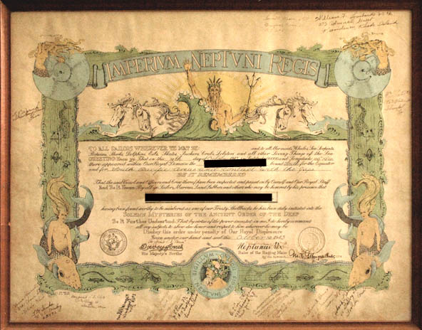
The ceremony of Crossing the Line is an initiation rite in the Royal Navy, U.S. Navy, U.S. Coast Guard, U.S. Marine Corps, and other navies that commemorates a sailor's first crossing of the Equator. This tradition is an event no sailor forgets.  Those inducted into the "mysteries of the deep" by Neptunus Rex and his Royal court, count the experience as a highlight of their naval career.  Neptunus Rex's party may and usually will include Davy Jones, Neptune's first assistant, Her Highness Amphitrite, and a long list of characters limited only by the veteran members imagination. Sailors who have crossed the Equator are nicknamed (Trusty) Shellbacks, often referred to as Sons of Neptune; those who have not are nicknamed (Slimy) Pollywogs.
Here is a sample certificate of completion of the Shellback Initiation from the 1940's I found on-line:

Mission of Good Will:


USS EUGENE A. GREENE (DD-711) - a Gearing-class destroyer, operated along the east coast and in the Caribbean acting as plane guard for pilots in carrier operations. From her home port in Norfolk she sailed to Guantanamo Bay for training early in 1947 and on 13 February sailed in a task group bound for Montevideo Uruguay to participate in the festivities accompanying the inauguration of Uruguay's president. The group also paid a good will visit to Rio de Janeiro before returning to Norfolk, 31 March.


1951:
Fast forward four years. Little did my family know it but 1951 was to be a year of big changes. My 18 year old mother and 21 year old father get married. About nine months into the year I am born on September 4th and in between the Thanksgiving and Christmas holidays my father dies tragically at a very young age. Indeed a year of changes…


November 28th, 1951, just after dark, my father is driving a loaded truck with two Navy buddies as passengers. A drunk driver swerves into a corner striking and overturning the truck in a terrible crash. The accident and the resulting account were witnessed by a taxi driver and his fare traveling the same route. My father thrown clear of the wreckage appears to have only scrapes and bruises. One of the passengers climbs out of the truck dazed from the impact but the other fellow is trapped. Realizing the situation my father attempts to rescue his trapped buddy. During the impact the fuel tank of the truck had ruptured and during the rescue attempt the battery shorted, sparked and ignited the pool of gasoline. My father and his trapped buddy were engulfed in a ball of fire. The trapped passenger died on scene. My father survived a week and died in intensive care in the hospital December 3rd, 1951. I was one day short of three months old. As a result of this terrible occurrence the paternal and maternal sides of my family fell into grief, despair, anger and confusion. There was an emotional explosion that severed the family and spun us off in different directions, parts of which would never reunite.


FOOTNOTE:
Looking back over the years, I realize that coming to terms with the death of my father and it's subsequent family aftermath has been a life long process for me. Throughout the early years of my life the subject was taboo for various reasons - children learn these lessons well, sometimes too well. In the 70's I was too busy building my own life and simply let the status quo stand. In the mid 1980's I connected with the West Coast branch of my family (my father's sister, Aunt Pat had married and moved west to raise her family there). God bless them all I was received with open arms. Later I traveled back to the East Coast and met with my Grandmother and two other Aunts. It was a wonderful reconnecting but my Grandfather had died and I deeply regret to this day not reuniting with him. Time, distance, economics, and unfortunately patterns of life, have been a challenge to staying in touch.
Although born John Lawrence Fanning III, I grew up with the name John L. Foster. In the 1990's I legally changed my name to J. Foster Fanning, honoring both my blood father and my step-father. Shortly there after my son changed his family name from Foster to Fanning in honor of his Grandfather who lost his life trying to save a friend and fellow serviceman.

WHAT GOES AROUND COMES AROUND:
My half brother Rick died in a car crash when he was a young man leaving a son and daughter behind. Once again, although under differing circumstance (mostly economical) there was a family estrangement occurring. Several years later in coming to terms with what was happening I stepped in and managed to bring the
teenage children of my half-brother back into contact with my mother and other brothers. Fortunately we have remained in contact to this day...




Tuesday, October 4, 2011

Golden Tiger Pathway

The last entry I managed to upload here was clear back in July. Gads! How is it that life buries us under such minutia of details we are always short of time? Speaking of which, here is a short story I'll share before I get to the topic I want to cover in this posting:

GET YOUR ASS IN GEAR:
One day a farmer's donkey fell down into a well. The animal cried piteously for ...hours as the farmer tried to figure out what to do. Finally, he decided the animal was old, and the well needed to be covered up anyway; it just wasn't worth it to retrieve the donkey.


He invited all his neighbors to come over and help him. They all grabbed a shovel and began to shovel dirt into the well. At first, the donkey realized what was happening and cried horribly. Then, to everyone's amazement he quieted down.


A few shovel loads later, the farmer finally looked down the well. He was astonished at what he saw. With each shovel of dirt that hit his back, the donkey was doing something amazing. He would shake it off and take a step up.


As the farmer's neighbors continued to shovel dirt on top of the animal, he would shake it off and take a step up. Pretty soon, everyone was amazed as the donkey stepped up over the edge of the well and happily trotted off!


MORAL :
Life is going to shovel dirt on you, all kinds of dirt. The trick to getting out of the well is to shake it off and take a step up. Each of our troubles is a steppingstone. We can get out of the deepest wells just by not stopping, never giving up! Shake it off and take a step up

* * *
Golden Tiger Pathway

Near the small mountain town of Republic WA, deep in the Okanogan Highlands, on the foothills of the Kettle River Range there is a 27 mile long stretch of abandoned railroad grade running from the town north to the Canadian Border. The first three miles of that grade have been partially surfaced over and form what is known at the Golden Tiger Pathway, which is the portion I'll mention here. The rest of the grade is now a part of the Ferry County Rail-to-Trail system (see Ferry County Rail Trail, ).
The western gateway to the Sherman Pass Scenic Byway also marks one of the parking / entrances to the Golden Tiger Pathway near Republic, WA. Photography by J. Foster Fanning
The southwestern entrance to the Golden Tiger Pathway is near Republic, WA. has two small parking lots, one located across State Highway 20/21 from the high school football field. The other entrance is at the Sherman Pass Scenic Byway sign along side Hwy 20/21.

The Golden Tiger Pathway has both an improved and unimproved surface.
Photography J. Foster Fanning

The pathway is well separated and above the state highway and for the most part is usually uncrowded. Often I find myself the only person walking or cycling the trail.  


An interpretative sign along the Golden Tiger Pathway.
Photography J. Foster Fanning
 There are some interpretative signs along the trail and I think the plan includes more as funds come available.


Big Gib, a steep mountain face overlooking the town of Republic WA seen from the Golden Tiger Pathway.
Photography J. Foster Fanning
This is a late summer image of Big Gib, the mountain overlooking the town of Republic. The vistas of the pathway have distinct seasonal changes as the cycle of seasons occur. The pathway is groomed for cross country skiing during the winter months.
A bench overlooking one of the many vistas of the Golden Tiger Pathway.
Photography J. Foster Fanning

I'll close this posting with this image of an inviting bench overlooking one of the many vistas of the Golden Tiger Pathway. If your in the Republic area this is definitely a walking or cycling path worthy of a visit.


For more info regarding the Ferry County Rails-to-Trails
http://www.ferrycountyrailtrail.com/

Sunday, July 3, 2011

Cooking with Beer...


Brauts and Brew have a long history extending over the grill, atop the stove and in the oven. What I’ve found important, through trial and error, is the relationship to temperature, moisture content, elevation, barometric pressure and latitude during the cooking process. Thus when our friends and proprietors of the Republic Brewing Company launched a Beer Cook-off with the judging based on “Recipes judged for: deliciousness, difficulty and strategic use of beer” I knew a definite advantage in the ‘strategic’ use of beer category.

Now ‘deliciousness’ is an altogether different element but confidence held with the use of Louisiana Hot-link Sausages bathed throughout a ten hour simmer in a frothy, rich brown beer from said taproom carried home in a four pint growler.

So in the end all that remained was the ‘difficulty’ portion of the prerequisites. Hmm, lets see my riverhome kitchen is at 1,850 elevation, 48*52’.59” Latitude, with the current barometric pressure of 29.78 and steady, with a ten hour preparation duration the cooking temperature had to be ~ well, you get the picture. Thus my recipe:

Beer Bath Louisiana Hot-Link Sausages

• One pack of Louisiana Hot-Link Sausages

• 1.5 pints of Republic Brewing Company’s Fit Brown Brew

• A dash of Sweet Baby Ray’s BBQ sauce

• One large crock-pot

• Ten hours of on-&-off cooking (mostly on)

Combine the contents into the crock pot early in the day. Periodically check the progress. During each inspection pour one quarter cup of Fit Brown Brew into a measuring up and drink slowly. If your measurements are done correctly the growler will be empty and the sausages cooked at the end of the ten hour period.

Catherine's Frothy Fit Brown Brewbread

3 cups organic all-purpose flour
2 Tablespoon organic granulated sugar
1 Tablespoon baking powder
1 teaspoon salt


Mix dry ingredients together and add your favorite spices and cheese.
A dainty shake of locally grown and dried Dill
2 Tablespoons of Feta


Add:
12 ounces of Frothy Fit Brown Brew from Republic Brewing Company’s take home growler.


Mix lightly batter will be thick. Add more beer for a thinner loaf.
Spread into a buttered 8 inch loaf pan.


Glaze: 1 brown home grown organic egg & 2 teaspoons Frothy Fit Brown Brew, well beaten
Cook at 375* for 45 minutes.

Bon Appétit...


Monday, June 13, 2011

Republic Brewing Company

Nestled in a mountainous valley within the Kettle River Range in the Okanogan Highlands, Republic Brewing Company and their new ale house, located in the historic fire hall downtown, Republic Wa is a establishment to wile away a spare hour or two enjoying locally crafted ales.
Does your fortune smile and guide you there on a warm and sunny afternoon? If so you are likely to enjoy the outdoor atmosphere as the big firehouse doors open letting the fresh air of a quaint, two lane, five block main street into the pub. Want a little more privacy? Drift back to the end of what once was two bays housing fire apparatus to find a comfortable couch and stuffed chairs arranged with conversation in mind. If your ready to mingle with the eclectic mixture of locals including mountain folk, miners, loggers, cowboys and everyone in between, saddle up to the custom built bar, inlaid with thousands of unique bottle caps, and order your choice of fine refreshment.

With the 'fire house' door open the mountain fresh atmosphere of the Okanogan Highlands blends with an eclectic mixture of locals.
From the Republic Brewing Company website:

Republic Brewing Co. & Fire Hall History

"We are not the first Republic Brewing Company. The original brewery operated 3 miles east of the current location, providing beer to gold miners from the 1890’s until it closed at the onset of Prohibition. Beer was served to local saloons in wooden barrels and bottled at the Republic Bottling Works, a building that currently serves as the San Poil Grange Hall."
One of our local 'official' tasting teams taking their task seriously...
  Of our tapmasters? Again from the Republic Brewing Companys website:

"Republic Brewing Company is owned and operated by Billy and Emily Burt both long-term locals of Republic, WA. They share a vision to provide excellent, locally made beer in a relaxed taproom where people can slow down and sip a pint. Advocates of living simply, they enjoy Ferry County because of the scenic and remote natural areas, excellent hunting and the wonderful, kooky locals."


A panoramic image of the Republic Brewing Company pub in downtown Republic WA.

 I'll close now with this "cheers" to you and hope that the long and winding road you are traveling will lead your road weary feet to our local pub for a pint and sometime spent with the good patrons of the Okanogan Highlands...
CHEERS!
Foster

Monday, May 23, 2011

2011 Spring run-off - Kettle River Rising...

On May 17th the Kettle River achieved a flow rate of 18.32 vertical feet according to the National Weather Service NOAA Advanced Hydrologic Predictive Services. The highest flow of water for this river since 05.21.08. Army Corp of engineers rates Flood Stage for this area at 18.5 feet. On 05.22.06 we hit 20.18, nearly two feet higher than these images taken today. But there’s a lot of snow in the Monashee Range of central British Columbia, the head waters for the Kettle River. Anticipate another substantial rise in the river within the next two weeks with continuing episodes until mid June.
Below is what the NOAA Advanced Hydrologic Predictive Services graph looked like for that day. A point to note low water is roughly 9 feet on this graph.

It takes a bit more water under the bridges to dampen the town of Curlew on the banks of the Kettle River seen in this image from that same date.
Here are some historic high water marks of the Kettle River near Curlew WA.

Historical Crests
(1) 21.15 ft on 05/29/1948
(2) 20.54 ft on 05/27/1942
(3) 20.18 ft on 05/22/2000
(4) 19.69 ft on 06/01/1972
(5) 19.60 ft on 05/21/1956
(6) 19.52 ft on 05/14/1971
(7) 19.37 ft on 05/30/1983
(8) 19.30 ft on 05/20/1957
(9) 19.17 ft on 05/29/1986
(10) 19.12 ft on 05/20/1954
Will close this session with this final image from May 17th 2011 with the forecast for higher water to come this year at the Canadian Monashee's release an unseasonable deep snowpack into the vallys below.


Monday, March 7, 2011

Land Locked Sailors Head West…

This is a long winter in the Pacific NW. Especially here, in NE Washington, it feels even longer than many other areas as we still have several inches of concrete-like snow in the mountain valley’s. So it was with pleasant anticipation we recently packed our bags for a westbound trip over the Cascade Mountains and onto the snowless, coastal plains to visit the village of Seattle. Okay, I’ll concede that for the most part Seattle, with over 582,000 folks, passed the village mark sometime ago. Still there are village like qualities to Washington’s most populace city.
This is a rendered image from two of my photographs. The foreground is a portion of
one of two cedar totem poles, designed by Victor Steinbrueck and carved by
James Bender in 1984.


While we may think of the founding of Seattle as the arrival of the Denny Party in 1851 the area has been inhabited since the end of the last glacial period approximately 8,000 years ago. When nautical explorers first arrived the indigenous peoples, now called the Duwamish Tribe, were living in several villages scattered over the coastal plains where Seattle is located. My partner Catherine and I appreciate the very active native culture within the current mosaic of peoples in the greater Seattle area.

One of the things making this trip to the coast special is that a friend arranged for our party to spend our week in residence in a downtown condo located on Alaskan Way overlooking Elliott Bay. As sailors this was a near perfect match of shore-side accommodations with fantastic access to the waterfront.

A view from the Alaskan Way condo looking into Bell Harbor Marina
- photo J. Foster Fanning


While our arrival was marked with a big late winter thunder front, complete with heavy winds, driving rain and pockets of hail, it was only a matter of hours before the late afternoon sun made an appearance and coaxed us into an evening walk up to the Pike Place Market.


Seattle is a unique community. Here are some interesting facts about the Emerald City...


Seattle is ranked the most literate city by Central Conn. State Univ. Everybody reads here. The Seattle Public Library system has the highest percentage of library card-holders per capita in the country.


Seattle was the first American city to put police on bicycles. Seattle has the highest percentage of people riding bikes to work compared to other US cities its size.


In 1961, the restaurant atop the Space Needle became the country's first revolving eatery.


Seattle's total land area? 53,718 acres of which 6,189 acres are parks and open areas. That's 11.52%! The parks in Seattle rock. The Port of Seattle parks in town are hidden gems awaiting discovery.


And last but not least...


The Farmer's Market at Pike Place Market is the longest continuously operating farmer's market in the US (1907). So speaking of the Pike Place Market...


Pike Place Market with a partial view of downtown Seattle skyline.
Photo J. Foster Fanning
 My first visit to the market was in 1969, not long after my arrival in Washington State. What a delightful experience the Market was then and remains so now. The market is a destination unto itself. And our temporary abode was just four flights of outdoor stairs below the market. It was a fun experience hiking up to this unique landmark each day.


Pike Place Market overlooks the waterfront in downtown Seattle. Its a place of business for many small farmers, merchants, craft folks, street musicians and peddlers. Also known as the Public Market it remains one of Seattle's most popular destinations and sees 10 million visitors annually.


Built on the edge of a steep hill the Market consists of multiple levels located below the main street entrance. Each layer features a variety of unique shops and stalls. Antique dealers, family-owned cafes, pubs, restaurants and vendors of the unusual and sometimes arcane give a somewhat third world feel to this unique market.

A tidy looking pilothouse seen at the Bell Harbor Marina.
Photo J. Foster Fanning


Our lodging is on the fourth floor over-looking the Bell Harbor Marina, which bills itself as “Seattle's only downtown recreational marina.” Situated at Bell Street Pier #66, boaters can tie up amid Seattle's main waterfront that includes easy access to Pike Place Market, Seattle Center The Space Needle, and Aquarium. The marina offers accommodations for approximately 70 boats, 30 to 150 feet. Guest moorage is available year-round.
Pier 66, Bell Harbor Marina and the waterfront condos.
Photo J. Foster Fanning


Later during one second day on the Elliott Bay waterfront the HMCS ALGONQUIN (DDG 283) a Canadian air defence destroyer arrived on Pier 66. A bit of on-line research revealed this ship was built in the 1970s, early in the 1990s it was extensively converted and refitted with sophisticated anti-air weapons systems, an improved propulsion plant, and advanced weapons and communications systems. The advanced communications capability combined with extra accommodations make ALGONQUIN sophisticated command and control platform. In peacetime, ALGONQUIN can employ its high-tech systems for a variety of missions, from search and rescue to fisheries and sovereignty patrols. The vessel's homeport is Esquimalt, British Columbia, on Vancouver Island.
HMCS ALGONQUIN approaching Pier 66. Photo J. Foster Fanning


Above I mentioned the influence of our native population on the Seattle area but the influence extends across the much greater geo-political area of the Pacific Northwest. The name ALGONQUIN means "At the place of spearing fish and eels" . Its name was connected to a First Nations People who ranged throughout a territory from Georgian Bay in the West, to the St. Maurice River in the East and who made their living by hunting and fishing.


M/V WENATCHEE on an evening sail approaching Seattle waterfront.
Photo J. Foster fanning
Third day, whilst Catherine, Clementine and Lacey worked with the Burke Museum, I met a friend who purchased a home near Port Madison a few years back and invited me out for a tour. We boarded the WA State ferry, M/V Wenatchee, for a short cruise to Bainbridge Island. “Wenatchee” is derived from the Yakima word wenatchi for "river flowing from canyon." In their journal Lewis and Clark mentioned the word “Wenatchee” during their travels through the Columbia River valley in 1803-1805. In our case the M/V Wenatchee is a Jumbo Mark II, 460' 2" Auto/Passenger Ferry with a 90’ beam, 16,000 hp engines that can push the vessel along at 18 knots. The draft is 17’3” and it carries a maximum of 2,500 passengers, 202 vehicles. Not only was it a sunny crossing but we fetched along side a regatta rounding a small islet south of the entrance to Eagle Harbor on Bainbridge Island.
Regatta rounding the mark off Bainbridge Island March 5th, 2011. Photo by J. Foster Fanning
Sunday morning found our party at the doors of the Seattle Aquarium, as soon-to-be-members of this fine establishment. The next few hours were spent touring the 7th largest Aquarium in the U.S. by attendance (Puget Sound region's 3rd largest paid visitor attraction). The Aquarium opened it’s doors in 1977 and has expanded ever since hosting over 20 million visitors since it’s grand opening.
Tide pool, Seattle Aquarium. Photo J. Foster Fanning

The invitation from a couple of other sailors led us to the Palisades inside the break-waters of Elliot Bay Marina on Sunday afternoon. And what a fine afternoon it was starting out in the sunshine on the southern deck of the establishment with a good glass of wine and a perfect view overlooking several hundred moored vessels. Soon our hosts arrived from an overnighter on their beautiful 38’ vessel and we joined them aboard for refreshments and conversation of the boating lifestyle.

Elliott Bay Marina from the deck of the Palisades.
Photo by J. Foster Faining


While we may not have trimmed a sail or set a course, or even traveled across the water, except for a ferry ride, a visit to Seattle’s waterfront goes a long way toward sating that dreaded ‘cabin fever’ and giving us hope that the winter tarps will soon be off our vessel and we will be under way again. See you out there…

Our hosts ~ Deborah and Marty aboard THREE SHEETS NW. Photo J. Foster Fanning

"Not all who wander are lost." JRR Tolkien

Saturday, February 12, 2011

The Raven and the River...

Recently while driving north into Curlew, crossing the Kettle River highway, bridge I encountered a raven flying a parallel course. Slowing my vehicle to match the flight of the bird I noted it was flying about 28 mph. It was a large raven and only about fifty feet west of my truck as we approached the bridge. So close I could clearly see the bird, the fluctuations of it's feathers in flight, and noted it’s mouth moving, possibly cawing, but it is a cold winter’s morning and my windows are up, I cannot hear if it is indeed making sound.


In flight toward the river the raven stayed at the same elevation above the western field, keeping it clearly in my view and with no other traffic I matched speeds with the bird and watched it fly alongside my vehicle. We both approached and then began to cross the river together. I, within my truck and in the structure of the overhead trussed bridge, the raven in the free, clear, cold air of a winter’s morning. Side by side the raven and I crossed the river less than fifty feet apart and nearly the same elevation above the water. As we reached the northern shore I realized what strange a thing had just happened. I had recently been reading a historical account of traveling in this northwest country 200 years ago. Rivers were not so casually crossed, nevertheless at 28 miles per hour in the company of a bird, which figures so prominently in the indigenous peoples ancient tales of creation. As we cleared the bridge the raven veered course and flew right over the top of my truck less than 20 feet above me. At that time it vanished from my sight, but not from mind…

Friday, February 11, 2011

Who's Got Cabin Fever?

Cabin Fever?

Wikipedia’s got it wrong. They say, “Cabin fever is an idiomatic term for a claustrophobic reaction that takes place when a person or group is isolated and/or shut in, in a small space, with nothing to do, for an extended period”... Not.


As a northern sailor I know cabin fever. Get it every year about this time. It’s a reaction that takes place when I’m isolated from my boat for over three months with another two months of winter weather to go. I know the symptoms really well. That pacing back and forth in front of the fireplace, which has already consumed far too much firewood. The tired eyes from rereading my favorite sailing books, TREKKA, MAIDEN VOYAGE, WORLD CRUISING ROUTES. Some years I reread all 21 books of the Jack Aubrey adventures by Patrick O’Brian. And then the anticipation, oft near desperate, while awaiting the next issue of Cruising World to sate my fevered hunger. Yep, I got it ~ bad…


Sometimes the only cure is for Catherine to tuck me into our loft berth and whilst I recover sipping medicinal rum she will read me excerpts from our cruising logbook...

“We dropped the hook in the small cove between Hellsgate Island and the towering cliffs of basalt forming the northern wall of the anchorage. The water was calm and taking on a hint of golden from the setting sun. After a long day passage it is most always refreshing to bring the vessel to a stop. Secure the hook in good holding sand, let out a hundred feet of chain, and take a deep breath in the cockpit. Not another boat in sight. No roads. No houses. Just a crescent, sandy beach bordered to the north by the tall dark cliffs and a small, steep walled, uninhabited island between us and the body of Roosevelt Lake and the main channel of the Columbia River. As the vessel and crew settle to quiet we spy a mother whitetail doe with a near grown fawn moving quietly from their browse under the bitterbrush and into the shadows of a lone copse of ponderosa pines. Canadian geese call in their flight overhead, vanishing into the dark but colorful western sky. As Catherine and I touch glasses in a toast to another evening aboard I note the sky and the merlot are of the same color and a smile crosses my lips thinking to myself, “we are drinking the sky”.

With that I’ll drift into a pleasant sleep, dreaming of bright sails and warm breezes, a good old boat and well found mate. Secure in the knowledge winter will pass…


Here's to your health...
Foster